
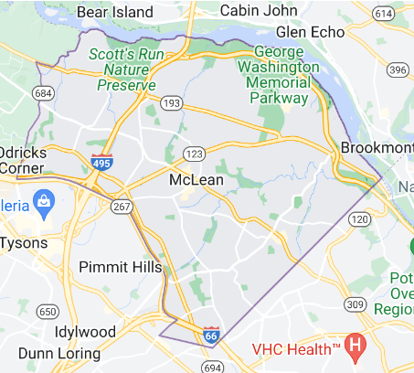
Mclean
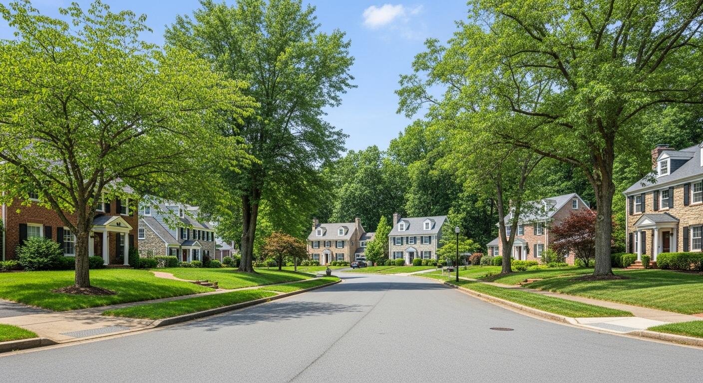
McLean is a natural home for executives, retired officials, senior partners, and those who want proximity to the capital without living inside it. The community’s character — understated, private, professionally connected — reflects the people who choose it.
QUICK FACTS AT A GLANCE
Community Type: McLean is an unincorporated community — it has no mayor, city council, or independent municipal government. It is part of Fairfax County and all residents are served by county-level institutions.
ZIP Codes: 22101 & 22102 (both USPS-designated McLean)
Population (2020): 50,773; median age 46.6 · ~2,001 residents per square mile
Total Area: 24.88 sq mi
Distance to Washington, D.C.: ~8 miles northwest via I-495 or George Washington Memorial Parkway
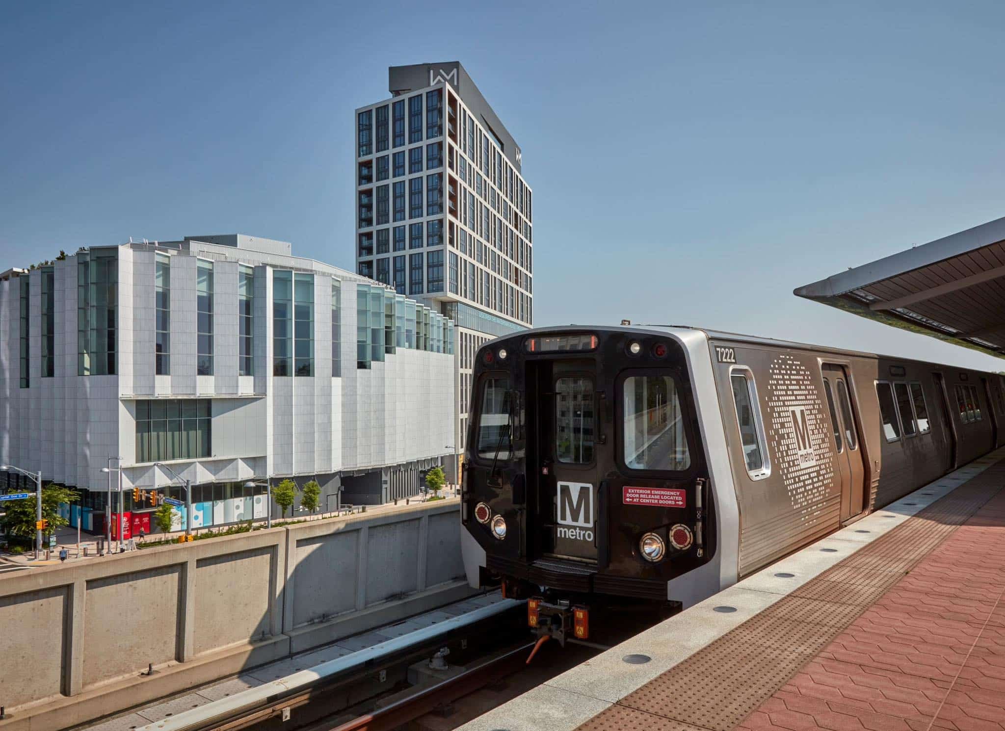
Metro & Transit Access: Served by WMATA Silver Line; stations include McLean and Tysons
School District: Fairfax County Public Schools (FCPS); two pyramids: McLean High School & Langley High School
Median Household Income: $250,000+; ACS 2024 (top-coded) · per capita ~$131K
Fun Fact: Named for John Roll McLean, Washington Post publisher (est. 1902)
Overview & Geography
McLean is located on the western bank of the Potomac River in Northern Virginia. The community spans 24.88 square miles of gently rolling Piedmont upland, with the Potomac River forming its northern and eastern boundaries. Several small tributaries — Bull Neck Run, Scott Run, Dead Run, Turkey Run, and Pimmit Run — flow north through the area, carving the wooded ravines and natural buffers that give McLean its heavily treed character.
McLean was named for John Roll McLean, then-publisher of The Washington Post, who co-purchased the charter for the Great Falls and Old Dominion Railroad in 1902. That rail investment spurred the first residential development and established the community's name. The Langley sub-community within McLean's eastern portion predates this, with roots in colonial-era land grants, and remains the location of the Central Intelligence Agency headquarters today.
NAMED NEIGHBORHOODS & COMMUNITIES
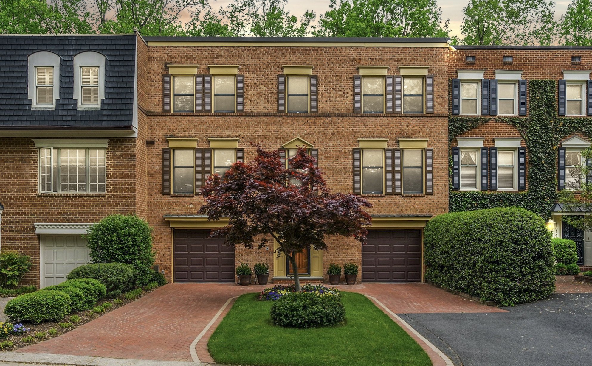
Langley — Langley is one of McLean’s most prestigious residential areas. It is known for large homes, wide lots, quiet streets, mature trees, and a very private feel. Many homes sit on generous parcels, giving the neighborhood a calm, estate-like setting just minutes from Washington, DC.
Chain Bridge Forest — Chain Bridge Forest is a quiet, wooded neighborhood near McLean, Arlington, and Washington, DC. It sits close to Chain Bridge, North Glebe Road, and the George Washington Parkway, giving residents a peaceful setting with fast access to the city.
The Reserve — The Reserve is one of McLean’s most private and polished luxury neighborhoods. Set behind gates and surrounded by mature trees, it feels quiet, secure, and tucked away. Homes here are large custom estates, often with grand entries, big lots, three-car garages, outdoor living spaces, and room for pools, gyms, theaters, and guest suites.
Salona Village — Salona Village is one of McLean’s quiet luxury neighborhoods: small, established, leafy, and close to everything. It has about 200 privately owned residential properties and sits south of Dolley Madison Boulevard, near downtown McLean, Pimmit Run Stream Valley Park, and Pimmit Bend Park.
Chesterbrook — Chesterbrook is one of McLean's most desirable close-in neighborhoods. Located along the eastern edge of McLean near the Virginia side of the Potomac River, it offers a rare combination of quiet residential streets, mature trees, large homesites, and an easy commute to Washington, DC.
Franklin Park — Franklin Park is one of McLean’s most loved luxury neighborhoods. It feels quiet, green, and private, yet it is close to Washington, DC, Arlington, Tysons, and downtown McLean. The neighborhood has about 250 single-family homes. Many sit on large, wooded lots.
Woodhaven — Woodhaven is a quiet, established neighborhood in McLean, Virginia, set near Old Dominion Drive and west of Spring Hill Road. It offers a classic McLean feel: leafy streets, generous lots, and a calm residential setting close to Tysons, downtown McLean, Arlington, and Washington, DC.
TRANSIT, COMMUTE & WALKABILITY
McLean offers solid regional access via Metro, major roads, and bus connections:
Metro (Washington Metropolitan Area Transit Authority):
Silver Line — McLean & Tysons stations serve the area
Orange & Silver Lines — West Falls Church, East Falls Church (nearby access)Bus Service:
Metrobus & Fairfax Connector link downtown McLean (Old Dominion Dr) to Metro stationsKey Roads:
I-495 (Capital Beltway), GW Parkway, Route 123, Route 7, Dulles Toll Road (VA-267)
Commute Times (Approx.):
Downtown D.C.: ~25–35 min (Metro) · ~25–45 min (car)
Reagan National Airport (DCA): ~20–30 min (car) · ~35–45 min (Metro)
Dulles Airport (IAD): ~25–35 min (car)
Pentagon: ~15–25 min (car)
Tysons: ~5–10 min (car)
Walkability:
Downtown McLean: Walkable (shops, dining, community center)
Tysons / West McLean: Most transit-friendly (Silver Line access)
Residential areas: Generally car-dependent
Average Commute: ~28 minutes
Parks, Landmarks & Community Life
Parks & Recreation
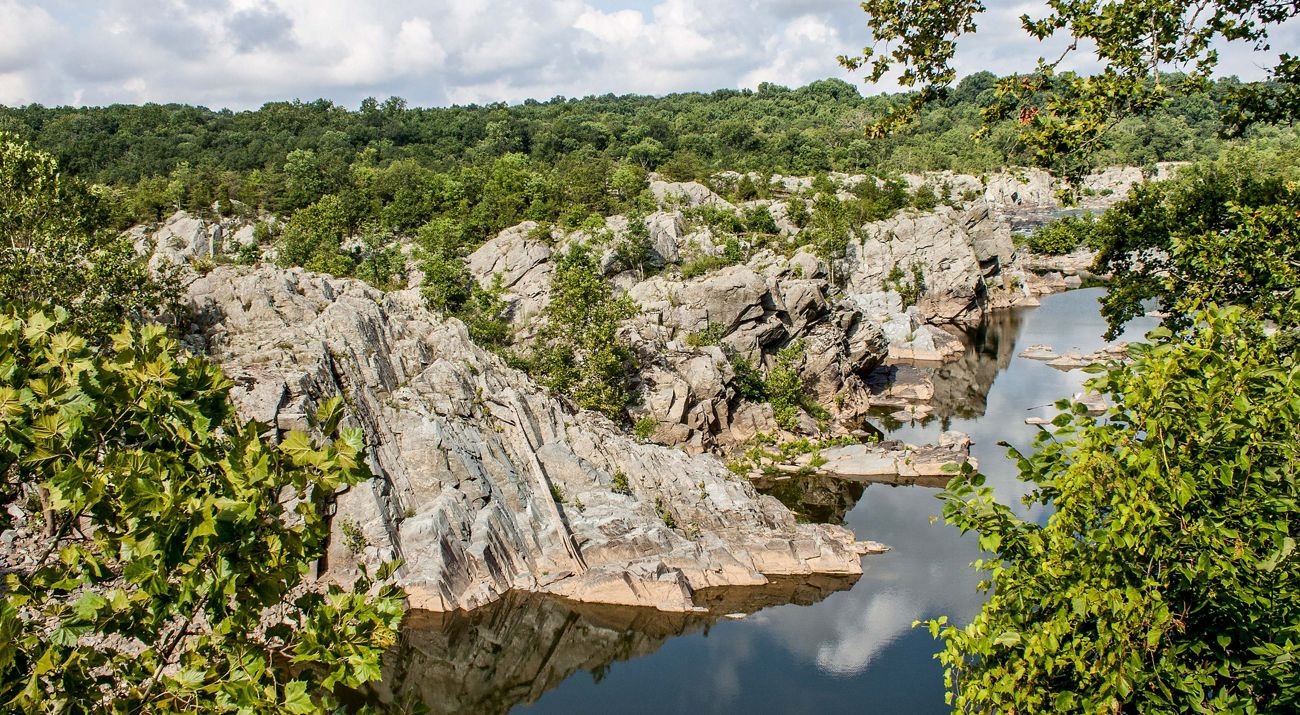
Great Falls National Park — Located directly adjacent to McLean's northern boundary along the Potomac; managed by the National Park Service; features the Great Falls of the Potomac, 15 miles of hiking trails, kayaking access, and Class V whitewater rapids. One of the most visited NPS sites in the entire D.C. Metro region.
Spring Hill RECenter — Recreation center in the Chesterbrook / Spring Hill neighborhood; indoor aquatics, fitness center, gymnasium, and court sports; a central hub for family programming in McLean.
McLean Community Center — Located on Ingleside Avenue in the downtown McLean core; offers year-round classes, performing arts productions, meeting rooms, and civic programming. Governed by the McLean Community Center Governing Board, which is elected by McLean residents.
Cherry Hill Village Green — Open public green in downtown McLean; hosts the summer concert series, community events, and the McLean Farmers Market. A gathering point for the McLean community throughout the year.
River Bend Country Club — Private golf and recreation club on the Potomac River; 18-hole course with river views; membership-based.
Scott's Run Nature Preserve — A 336-acre Fairfax County natural area along Scott's Run creek and the Potomac; popular hiking destination with a waterfall and swimming hole directly accessible from McLean neighborhoods.
Historic Landmarks
Hickory Hill — Historic estate in the Langley neighborhood; former home of Ethel Kennedy, widow of Senator Robert F. Kennedy; listed on the National Register of Historic Places.
Salona — One of McLean's oldest surviving properties, dating to the early 19th century; former home of Revolutionary War general Light-Horse Harry Lee, father of Robert E. Lee.
Langley Fork Historic District — National Register historic district encompassing 12 contributing buildings in the Langley neighborhood, including the Langley Ordinary, Langley Toll House, and Gunnell's Chapel.
George Bush Center for Intelligence (CIA HQ) — Not publicly accessible, but a defining landmark of McLean and of the intelligence community globally. The name 'Langley' — the sub-community within McLean where the campus sits — is used worldwide as a metonym for the CIA.
Shopping & Dining
Tysons Corner Center — One of the largest malls on the East Coast with over 300 stores including Nordstrom, Bloomingdale's, and Apple; directly accessible from Tysons Station on the Silver Line.
Tysons Galleria — Luxury retail destination adjacent to Tysons Corner Center; anchored by Saks Fifth Avenue, Neiman Marcus, and Macy's; Silver Line adjacent.
Old Dominion Drive corridor (downtown McLean) — Neighborhood-scale retail and dining district; home to McLean Family Restaurant, Balducci's Food Lover's Market, Amphora Restaurant, and numerous independent businesses and boutiques.
Community Events & Farmers Market
McLean Farmers Market — Operates seasonally at Cherry Hill Village Green; local produce, artisan goods, and prepared foods serving the McLean community throughout the growing season.
Summer Concert Series — Outdoor performances at Cherry Hill Village Green, organized by the McLean Community Center; a recurring seasonal tradition for McLean families.
McLean Community Center Programming — Year-round classes, theater productions, lectures, and civic events; one of the most active community centers in the region.

Frequently Asked Questions
Is McLean a city, town, or county?
McLean is none of these. It is an unincorporated community and Census-Designated Place (CDP) — a statistical designation used by the U.S. Census Bureau to measure population. McLean is an unincorporated community — it has no mayor, city council, or independent municipal government. It is part of Fairfax County and all residents are served by county-level institutions.
Which high school will my child attend in McLean?
It depends entirely on your specific address. McLean spans two high school pyramids: Langley High School and McLean High School. Do not rely on neighborhood names, ZIP codes, or maps to determine school assignment. Verify any address using the official FCPS School Locator tool.
How do McLean residents commute to Washington, D.C.?
The primary options are the WMATA Silver Line (McLean Station or Tysons Station) and driving via the George Washington Memorial Parkway or I-495 / I-66. By Metro, downtown D.C. is approximately 25–35 minutes from McLean Station. By car during off-peak hours, the drive can be as short as 20 minutes; peak-hour commutes to downtown range from 30–50 minutes depending on destination. The mean travel time to work for McLean residents is approximately 28 minutes (ACS 2024).
Why do some Tysons businesses list a McLean mailing address?
Because the U.S. Postal Service boundary for ZIP code 22102 — one of McLean's two ZIP codes — generally follows Leesburg Pike (VA Route 7). Businesses in Tysons Corner that are located east of Leesburg Pike fall within the 22102 postal zone and receive a McLean, VA 22102 mailing address, even though they are not within the McLean CDP boundary. This is purely a postal designation and does not affect school assignment, zoning, or community governance. For real estate decisions, always reference the CDP boundary, not the ZIP code.
What is McLean's connection to the CIA?
The Central Intelligence Agency's headquarters — formally known as the George Bush Center for Intelligence — is located at 1000 Colonial Farm Road within McLean's Langley sub-community. operations.
Our McLean Market Expertise
McLean is not one market: it is an estate corridor on the Potomac, a walkable downtown core, a set of school-driven single-family neighborhoods, and a transit-oriented density edge near Tysons — and each of these behaves differently.
Whether you are buying a Langley Farms estate, a townhome walkable to Cooper Middle School, or a condo at The Boro near the McLean Metro Station, our team delivers specific, data-grounded guidance tailored to your target sub-market and timeline. Contact us for a complimentary comparative market analysis (CMA) for any McLean address, or a guided tour of current listings.
Authoritative Resources for McLean Research
FCPS School Locator — Fairfax County Public Schools — The official tool to identify the exact elementary, middle, and high school assigned to any McLean address; reflects all current boundaries including the post-2021 adjustment.
McLean Community Center (mclean.cc) — Official site of the McLean Community Center Governing Board; lists recreation programs, civic events, summer concert schedules, farmers market dates, and community news.
WMATA — Silver Line Stations & Schedules — Washington Metropolitan Area Transit Authority's official site for Silver Line schedules, fares, parking at McLean Station and Tysons Station, and bus connection information.
Great Falls National Park — National Park Service — Official NPS page for Great Falls Park: trail maps, waterfall viewing areas, kayaking permits, visitor center hours, and entrance fee information.
Tysons Corner Center — Official website for Tysons Corner Center: store directory, dining listings, Silver Line walking directions from Tysons Station, and events calendar.
Scott's Run Nature Preserve — Trail Information — Northern Virginia Regional Park Authority page for Scott's Run Nature Preserve, which borders McLean neighborhoods along the Potomac River; includes trail maps and access information.
McLean Citizens Association (MCA) — Civic organization representing McLean community interests on planning, zoning, transportation, and local policy matters; publishes newsletters and community updates.
