
Washington DC
Quick Facts at a Glance
Jurisdiction Type: Independent federal district — not a state, county, or municipality within a state
Population: ~678,000 residents (2023 estimate)
Land Area: 68.34 square miles (61.05 square miles of land and 7.29 square miles of water)
ZIP Codes: Primarily 20001–20020, 20024, 20032, 20036, and other 200-series ZIP Codes
County: None — Washington, D.C. is a federal district
Adjacent Jurisdictions: Maryland (Montgomery and Prince George’s Counties) and Virginia (Arlington County and the City of Alexandria) along the Potomac River
Distance to Major Employment Centers: Serves as the nation's capital and central employment hub for the federal government, private sector, and international organizations
Metro & Transit Access: Washington Metro (WMATA) Red, Blue, Orange, Silver, Green, and Yellow Lines with more than 40 Metro stations within the District; DC Circulator and Metrobus provide extensive local and regional transit service
Avg. Metro Commute: Typically 15–40 minutes within the District, depending on origin and destination
Key Roads & Highways: I-395, I-295, I-695, New York Avenue (US-50), Constitution Avenue, Independence Avenue, and the George Washington Memorial Parkway connections
School Systems: District of Columbia Public Schools (DCPS) and DC Public Charter Schools, with more than 200 charter school campuses operating through a citywide lottery system
Established: Created by the Residence Act on July 16, 1790; became the seat of the U.S. federal government in 1800
Community Features: National Mall, federal government institutions, Smithsonian museums, historic neighborhoods, major universities, cultural venues, and extensive parkland
Walk Score®: Walk Score 77 (Very Walkable); Transit Score 79; Bike Score 71
Location: Situated along the Potomac River and bordered by Maryland and Virginia.
Overview & Geography

Washington, D.C. occupies 68 square miles on the eastern bank of the Potomac River, bordered by Maryland to the north, east, and southeast and Virginia to the southwest across the river. The district is divided into four quadrants — Northwest (NW), Northeast (NE), Southeast (SE), and Southwest (SW) — centered at the United States Capitol. The diagonal avenues named after states (most prominently Pennsylvania Avenue NW, Massachusetts Avenue NW, and Connecticut Avenue NW) overlay a grid of numbered and lettered streets. The National Mall — stretching from the Capitol to the Lincoln Memorial — forms the civic and geographic spine of the city.
The district was established by the Residence Act of July 16, 1790, which authorized President George Washington to select a site for a permanent federal capital. The original 100-square-mile diamond straddled both banks of the Potomac, but the Virginia portion (Alexandria) was retroceded to Virginia in 1846, resulting in the current 68-square-mile footprint. The federal government officially relocated from Philadelphia to Washington in 1800.
Major transportation corridors include I-95/I-495 (Capital Beltway) (which encircles the district), I-395 (connecting the district to Northern Virginia via the 14th Street Bridge), I-295 (along the eastern edge), U.S. Route 1, and Route 50 (New York Avenue NW). The Rock Creek Parkway and George Washington Memorial Parkway provide scenic commuter routes within and adjacent to the district.
Named Neighborhoods & Communities
Washington, D.C. contains more than 130 officially recognized neighborhoods, organized loosely by quadrant. The following are among the most active in the residential real estate market:
Kent — Kent is one of the most private and elegant neighborhoods in Northwest Washington, DC. Tucked between MacArthur Boulevard and Battery Kemble Park, it feels quiet, green, and residential while still being close to Georgetown, downtown DC, and major commuter routes.
Spring Valley — Spring Valley is one of Northwest DC’s most elegant and peaceful neighborhoods. It feels more like a leafy village than a city neighborhood, with wide lawns, mature trees, winding streets, and large classic homes.
Georgetown — Georgetown is one of Washington, DC’s most loved and most famous neighborhoods. It sits in Northwest DC along the Potomac River and is known for historic row homes, brick sidewalks, cobblestone streets, gardens, shops, restaurants, and the Georgetown waterfront.
Sheridan-Kalorama — Sheridan-Kalorama is one of Washington, DC’s most elegant and historic neighborhoods. It sits west of Connecticut Avenue, near Dupont Circle, Embassy Row, Rock Creek Park, and Adams Morgan. The area is known for grand homes, embassies, quiet streets, and classic DC beauty.
Massachusetts Ave Heights — Massachusetts Avenue Heights is one of DC’s most elegant and private neighborhoods. It sits in Northwest Washington near Embassy Row, Observatory Circle, Woodley Park, Cleveland Park, and the Washington National Cathedral.
Wesley Heights — Wesley Heights is one of Northwest DC’s quietest and most elegant neighborhoods. It feels calm, green, and private, yet it is close to Georgetown, Tenleytown, Spring Valley, American University, and downtown DC.
Berkley — Berkley is one of Northwest DC’s quiet luxury neighborhoods. It sits near Foxhall, The Palisades, Wesley Heights, and Georgetown. The neighborhood is known for large homes, leafy streets, and a calm, private feel.
Foxhall — Foxhall is one of Washington, DC’s most charming and tucked-away neighborhoods. It sits in Northwest DC, near Georgetown, Glover-Archbold Park, and the Potomac River. The area feels peaceful, green, and private, but it is still close to the heart of the city.
Burleith — Burleith is a quiet, leafy neighborhood in Northwest DC, tucked between Georgetown, Glover Park, Whitehaven Park, and Glover-Archbold Park. It feels calm and residential, but it is close to some of the best dining, shopping, schools, parks, and cultural spots in the city.
Chevy Chase — Chevy Chase is one of Northwest DC’s most loved “suburb-in-the-city” neighborhoods. It offers quiet streets, leafy sidewalks, classic homes, local shops, and easy access to the best of DC and nearby Maryland.
Woodley Park — Woodley Park is one of Washington, DC’s most graceful city neighborhoods. It feels green, calm, and classic, yet it sits close to some of the city’s best-known places.
Schools & Education
School assignment in Washington, D.C. is determined by residential address within the DC Public Schools (DCPS) boundary zone, with additional access to more than 200 DC Public Charter Schools through a universal lottery administered by My School DC. D.C. residents may apply to any charter school regardless of neighborhood.
Transit, Commute & Walkability
Metro Rail (WMATA)
The Washington Metropolitan Area Transit Authority (WMATA) operates six rail lines with more than 40 stations within D.C. borders. Key stations include:
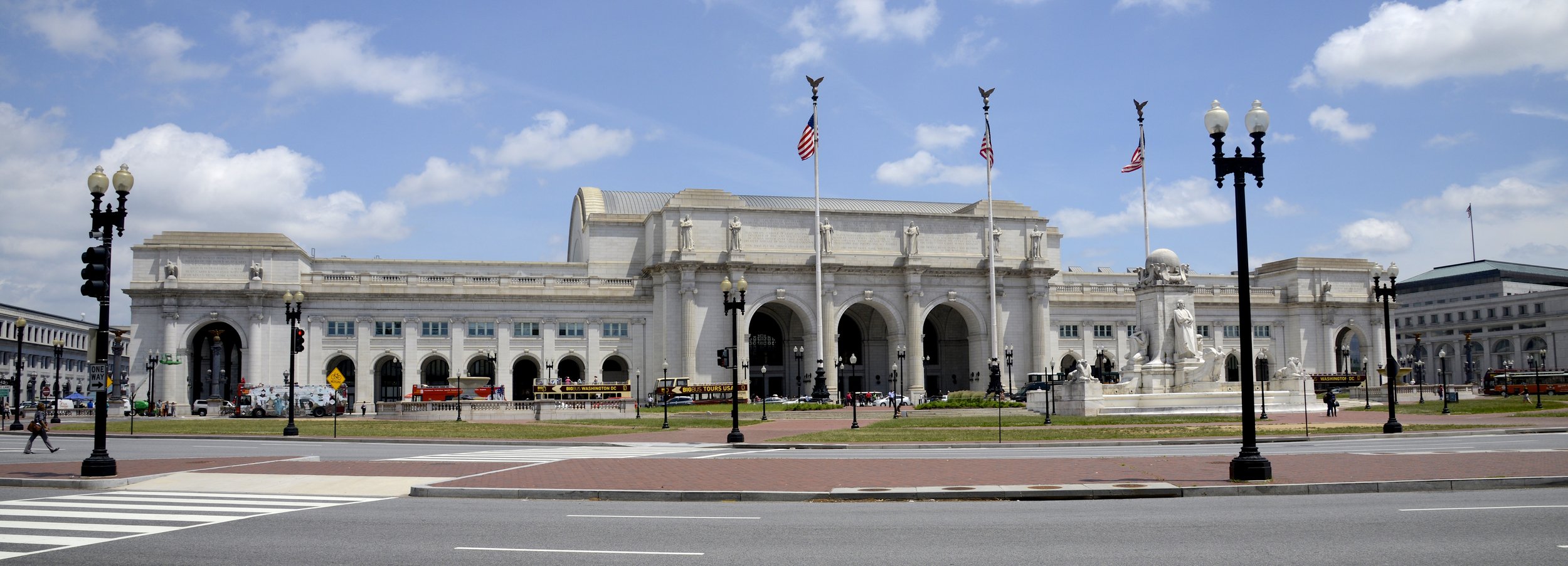
Union Station — Red Line; also a hub for Amtrak intercity rail, MARC commuter rail, and VRE commuter rail; located at Massachusetts and Delaware Avenues NE.
Metro Center — Transfer hub for Red, Blue, Orange, and Silver Lines at 12th and G Streets NW.
Gallery Place-Chinatown — Transfer point for Red, Green, and Yellow Lines at 7th and H Streets NW.
L'Enfant Plaza — Transfer hub for Blue, Orange, Silver, Green, and Yellow Lines; serves SW D.C. and federal buildings.
Foggy Bottom-GWU — Blue, Orange, Silver Line station near the State Department, Kennedy Center, and George Washington University.
Friendship Heights — Red Line terminal for many trains; serves upper NW D.C. and the Maryland border.
Navy Yard-Ballpark — Green Line; primary station for Capitol Riverfront, Nationals Park, and Audi Field.
Congress Heights / Southern Avenue — Green Line stations serving far SE/SW D.C.
Peak-hour headways on most lines run 4–8 minutes. Off-peak service runs every 12–20 minutes. Fares are distance-based, ranging from approximately $2.00–$6.00 per trip (2024).
Walkability & Bike Infrastructure
Washington, D.C. carries a Walk Score of 77 (Very Walkable), a Transit Score of 79, and a Bike Score of 71 as of 2024. The Capital Bikeshare system operates more than 700 stations and 5,000+ bikes across the district and neighboring jurisdictions. Major trail infrastructure includes the Rock Creek Trail (11 miles through the district), the Metropolitan Branch Trail (connecting Union Station to Takoma, MD), and the Anacostia Riverwalk Trail.
Parks, Landmarks & Community Life
Parks & Green Space
Rock Creek Park — A 1,754-acre national park (est. 1890) running north-south through the district, featuring horse trails, picnic areas, tennis courts, and the Rock Creek Trail.
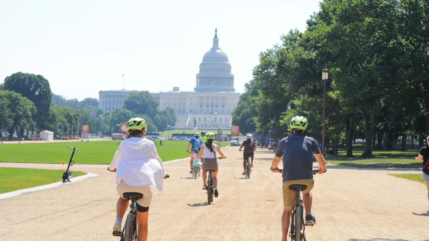
National Mall — A 2-mile greensward stretching from the Lincoln Memorial to the Capitol, flanked by Smithsonian museums and monuments; the symbolic and physical heart of the district.
Meridian Hill Park — A 12-acre National Park Service property in the Columbia Heights neighborhood, featuring a cascading fountain and frequent weekend drum circles.
Anacostia Park — A 1,200-acre NPS park along the Anacostia River in SE D.C., featuring athletic fields, water access, and the Kenilworth Aquatic Gardens.
Theodore Roosevelt Island — A 91-acre wooded island in the Potomac River, accessible only by footbridge from the Virginia side; managed by the National Park Service.
Kenilworth Aquatic Gardens — The only National Park Service site in the U.S. devoted to cultivating aquatic plants, featuring acres of lotus and water lilies in bloom each summer.
Historic Landmarks

United States Capitol — Construction began in 1793; the seat of the U.S. Congress. Address: First St SE.
The White House — Official residence and office of the U.S. President since 1800; located at 1600 Pennsylvania Avenue NW.
Lincoln Memorial — Dedicated in 1922; located at the western end of the National Mall on the banks of the Potomac.
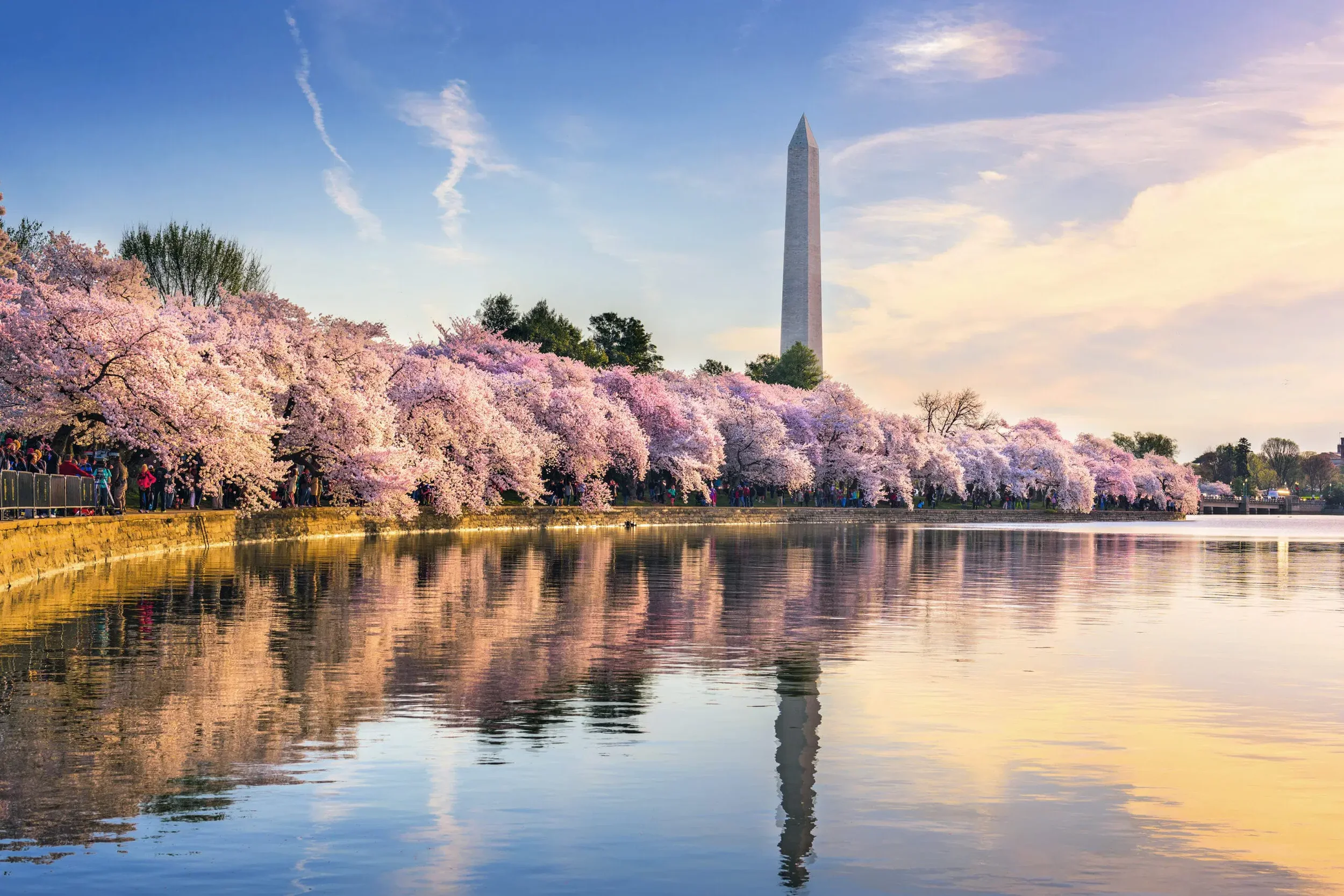
Washington Monument — Completed in 1884; at 555 feet, the world's tallest stone structure and the most prominent feature of the D.C. skyline.
Library of Congress — Founded in 1800; the world's largest library, located on Capitol Hill.
National Cathedral (Washington National Cathedral) — Construction began in 1907; the sixth-largest cathedral in the world, located at Massachusetts and Wisconsin Avenues NW.
Farmers Markets & Community Events
FRESHFARM DuPont Circle Farmers Market — Year-round Sunday market at 20th Street and Massachusetts Avenue NW; one of the largest producers-only markets in the mid-Atlantic region.
Eastern Market — Indoor and outdoor public market on Capitol Hill (7th Street and North Carolina Avenue SE), open year-round; a neighborhood institution since 1873.
DC Jazz Festival — Annual multi-venue festival held each June featuring local, national, and international jazz performers.
National Cherry Blossom Festival — Annual spring festival (late March–mid-April) celebrating the 1912 gift of cherry trees from Japan; attracts approximately 1.5 million visitors annually.
H Street Festival — Annual neighborhood block party on the H Street NE corridor, one of the largest street festivals in D.C.
Capital One Arena — Indoor arena at 601 F Street NW in Penn Quarter; home of the Washington Capitals (NHL) and Washington Wizards (NBA) and major concert venue.
Kennedy Center for the Performing Arts — The nation's busiest performing arts facility, located on the Potomac at New Hampshire Avenue NW; hosts more than 2,000 performances annually.
Frequently Asked Questions
What type of government does Washington, D.C. have, and how does that affect homeowners?Washington, D.C. is a federal district created by the U.S. Constitution, not a state or county. It has an elected mayor and a 13-member city council that exercise home rule authority under the D.C. Home Rule Act of 1973. Homeowners pay D.C. income taxes, property taxes (administered by the Office of Tax and Revenue), and federal income taxes, but D.C.'s non-voting Congressional delegate means residents have no full voting representation in the U.S. Senate or House of Representatives. \
What are the best neighborhoods in Washington, D.C. to buy a home?
The best neighborhood depends on buyer priorities. Georgetown, Chevy Chase DC, Spring Valley, and Cleveland Park consistently rank among D.C.'s highest-priced and most stable residential markets, characterized by large detached homes and tree-lined streets. Navy Yard/Capitol Riverfront offers newer condominium inventory with waterfront access, strong walkability, and proximity to the Green Line Metro. Columbia Heights and Shaw offer relatively more affordable rowhouse options with excellent transit access and a vibrant restaurant scene. Buyers prioritizing transit should focus on neighborhoods within a quarter-mile of a Metro station.
How do DC Public Schools work, and how is school assignment determined?
DC Public Schools (DCPS) is an independent school district serving the District of Columbia. School assignment is based on residential address — each address falls within a specific elementary, middle, and high school boundary. Parents can look up their assigned school using the DCPS 'Find Your School' tool on the DCPS website. In addition to boundary schools, D.C. residents have access to more than 200 public charter school campuses through an open enrollment lottery administered by My School DC. Charter school admission is not address-based; any D.C. resident may apply. Applications are typically due in mid-January for the following school year.
What Metro lines serve Washington, D.C., and which are most useful for commuters?
Washington, D.C. is served by all six WMATA Metro lines: Red, Blue, Orange, Silver, Green, and Yellow. The Red Line is the most extensive within D.C., running from Shady Grove (MD) through Union Station and downtown to Glenmont (MD). The Green and Yellow Lines serve Southeast D.C. including the Navy Yard/Ballpark area and Congress Heights. The Blue, Orange, and Silver Lines run through downtown and connect D.C. to Northern Virginia and suburban Maryland. For commuters traveling to Northern Virginia (Arlington, Tysons, Reston), the Silver Line is most direct. Commuters to Maryland suburbs should use the Red Line or Green Line depending on destination.
Our Washington, DC Market Expertise
Our team has represented buyers and sellers across Washington, D.C., from Capitol Hill rowhouses to new construction condominiums in Navy Yard and luxury properties in Northwest DC. We bring deep knowledge of D.C.'s unique jurisdictional landscape to every transaction.
Whether you are purchasing your first D.C. condominium, upsizing to a detached home in Cleveland Park, or selling an investment property in Columbia Heights, our agents provide current market analysis grounded in active MLS data, neighborhood-level insight, and professional negotiation expertise. We offer complimentary buyer consultations and seller market analyses for all D.C. properties. Contact us today to connect with a D.C. market specialist and take the first step toward your next move.

Authoritative Resources for Washington, DC Research
The following official and authoritative resources provide reliable, citable information for prospective buyers, sellers, and researchers. Each link is described by the specific content it contains:
DC.gov — Official Website of the District of Columbia — The official D.C. government portal, containing information on city services, agency directories, legislation, permits, licenses, and local government programs.
DC Public Schools (DCPS) — Find Your School Tool — The official DCPS school boundary lookup tool; enter a D.C. residential address to identify the assigned DCPS elementary, middle, and high school.
My School DC — DC School Choice Lottery — The DC government's unified lottery platform for applying to public charter schools; contains deadline information, school profiles, and application instructions.
WMATA — Washington Metro Trip Planner and Fares — The official WMATA website containing Metro system maps, station information, current fares, SmarTrip card management, and real-time service alerts.
DC Office of Tax and Revenue — Property Tax Information — The D.C. government office that administers property assessments, tax rates, homestead deduction applications, and real property transfer records.
National Park Service — Washington, DC Parks — The NPS listing of all national park units within Washington, D.C., including Rock Creek Park, the National Mall, and Anacostia Park, with visitor and program information.
Walk Score — Washington, DC — Walk Score's city-level and address-level walkability, transit, and bikeability scores for Washington, D.C., including neighborhood-by-neighborhood comparisons.
DestinationDC.org — Washington, DC Tourism & Events — The official destination marketing organization for Washington, D.C., providing a comprehensive events calendar, neighborhood guides, dining information, and attraction listings.
